


From the evolution of ancient supercontinents Gondwana and Laurasia 360 million years ago, to the collisions of Indian and Eurasian plates 65 million years ago, the book presents the birth of the Earth's highest summit. From the variation of vertical zonation, to the special natural resources of the third pole's cryosphere, the book showcases the forming process of the water tower from which the major rivers in Asia originate.
From the first scientific investigation on the 7,000 square kilometers on the east, north and west sides of Qomolangma in 1959 and 1960 to the second comprehensive investigation on the plateau in 2018 and 2019, the book shows the advancement of Earth System Science in China.
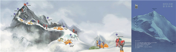
Humans started exploring the peak in 1921 with expeditions by British mountaineers. The book covers the moment when Chinese people first set foot on the top of the mountain in 1960 and other important moments featuring mountaineers from all over the world.
It also records the start of China's surveying and mapping of Qomolangma, which began during the Qing Dynasty (1644-1911), all the way to the most accurate ever recording of its 8,848.86-meter elevation in 2020.
On May 27, 2020, Tselo and his teammates stayed on the mountaintop for a record of 150 minutes. They did not plan to stay that long, because at an altitude above 8,800 meters, with the air containing only a little over 30 percent oxygen content compared to at sea level and a temperature of -40 C, it was a dangerous endeavor.

Presented by Chinaculture Registration Number: 京ICP备13028878号-4
Copyright © Ministry of Culture and Tourism, P.R.China. All rights reserved
Presented by Chinaculture Registration Number: 京ICP备13028878号-4
Copyright © Ministry of Culture and Tourism, P.R.China. All rights reserved


 京公网安备 11010502035176号