| |
Energy
( 2005-10-27 )
 Tibet Autonomous Region's complex topography and widely varying climates result in an abundance of natural resources. It is weak in energy resources such as coal, oil, and natural gas but rich in hydro, geothermal, solar, and wind energy. Rivers crisscross its 1.2-million-square-kilometer area, offering enormous potential waterpower. Tibet Autonomous Region's complex topography and widely varying climates result in an abundance of natural resources. It is weak in energy resources such as coal, oil, and natural gas but rich in hydro, geothermal, solar, and wind energy. Rivers crisscross its 1.2-million-square-kilometer area, offering enormous potential waterpower.
Tibet (Southeast China) produces approximately 200 million kilowatts of natural hydroenergy annually, about 30 percent of the nation's total. It has 354.8 billion cubic meters in surface water resources, 13.5 percent of the nation's total, and 330 billion cubic meters in glacial water resources. The southeast of the autonomous region has a hydroenergy capacity that contains about 70 percent of the region's surface waters. The
Yarlung Zangbo Rivermainstream has a natural hydroenergy capacity of 80 million kilowatts, which rises to 90 million kilowatts with the inclusion of its five tributaries of the Doxung Zangbo, Nyang Qu,Lhasa,Niya, and Parlung Zangbo rivers.
Tibet has about 56.59 million kilowatts in exploitable hydroenergy resources, 15 percent of the nation's total. Of particular importance is the Yarlung Zangbo River, with more than 47.37 million kilowatts in potential exploitable energy. Investigations have found more than 10 sites and sections of the river suitable for the construction of hydropower stations.
In the area between Paidi in Mainling County and Lidong Bridge in Medog County of the Nyingchi Prefecture, the river makes a U-turn, dropping 2,190 meters over the course of a famous 200-kilometer gorge. A 36-kilometer channel cut through the rock would allow the river to flow directly from Paidi to Lidong Bridge, where a giant 40-million-kilowatt hydropower plant could be built.
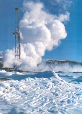
Investigations have found that Tibet leads China in geothermal energy. More than 600 geothermal sites -- including hotsprings, boiling springs, geysers, hot flow rivers, and exothermic ground surfaces, with an estimated heat discharge of 550,000 kilocalories per second (the heat equivalent being about 2.4 million tons of standard coal annually) -- have been located in the Nujiang-Jinshajiang-Lancangjiang tectonic zone, the Yarlung Zangbo rift zone, and the Nagqu-Nyemo rift zone.
The Yangbajain geothermal field in Damxung County, Lhasa is currently China's largest high-temperature steam geothermal field, and also one of the largest geothermal fields in operation in the world today.
|
|