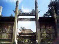
 The Wen Temple (temple in memory of men of letters) is situated in the southern corner of People's Road of Suzhou City, Jiangsu Province. It was established by Fan Zhongyan in the first year (1034) of the Jingyou reign of the Northern Song Dynasty when he worked as the magistrate of Suzhou County. Through expansion and rebuilding of many dynasties, it has become a very large temple, with many halls and rooms. According toThe History of Wuxian County, there were as many as 213 rooms in the Chunyou reign of the Southern Song Dynasty (1127-1279). Most of the extant buildings were reconstructed in the third year (1864) of the Tongzhi reign of the Qing Dynasty (1644-1911) except the Dacheng Hall. The Dacheng Hall has seven rooms in the west and four in the inner part. It has a roof with multiple eaves, and a spacious platform in front of the hall, looking very magnificent. The Wen Temple of Suzhou has become a museum of stele inscriptions, containing four big steles of the Song Dynasty (960-1279), namely the stele of geographical map, the stele of astronomical chart, the stele of lineage of emperors in China and the stele of Pingjiang City Map, with very high historic and scientific value.
The stele of geographical map is about the same size as the stele of geographical map, with the three characters in official script that mean geographic map inscribed in the middle of the top. What is inscribed is a topographical map of China in the Song Dynasty, divided into two parts: the upper picture part and the lower text part, being 1.24 m and 0.49 m high respectively. In the upper topographical map, the traditional Chinese map drawing technique is used, characterized by a combination between lines and images, to depict very clearly the mountain chains, the rivers, the forests, the Great Wall of China, and the geographic positions of every prefecture, region or army, etc. The 645 characters in 36 lines in the lower part of the stele record roughly the changing history of the Chinese territory from the Xia (21st century - 17 century BC) to the Song Dynasty. Compared with the contemporary topographical map of China, it is basically the same except for the great difference in coastline and the unclear information about the sources of the Yellow River and the Yangtze River. Together with theHuayitu(map of China) and theYujitu(picture of Traces of Emperor Yu) of Xi'an, the three maps are the oldest national maps of China in existence.
The stele of geographical map is 1.90 m high and 1.08 m wide. It was made in the seventh year (1247) of the Chunyou reign of the Southern Song Dynasty. In the middle of the top is an incised inscription in official script that means stele of astronomical chart. The stele is divided into the upper and the lower parts, being 90 and 70 cm respectively. In the upper part is a round map of all the sky, and in the lower part is an explanatory text. The star map takes the north celestial pole as the center, uses three concentric circles (the circle of perpetual apparition of the north pole, the astronomical equator and the circle of perpetual occultation of the south pole) plus the lines of the twenty-eight lunar mansions to display the universe, containing 280 constellations and 1,343 fixed stars. According toHistory of the Yuan Dynasty(1271-1368), people carried out star observation for four times in the reigns of Jingyou, Huangyou, Yuanfeng and Congning of the Song Dynasty, and this picture was drawn in accordance with the observation of the Yuanfeng reign (1078-1085). The narrative text in the lower part contains 2,140 characters in 42 lines, briefly explaining the universe, the earth, the north pole, the south pole, the equator, the hosts of heaven, the causes of solar eclipse and lunar eclipse, and the astronomical knowledge of that time, reflecting the level of Chinese ancient astronomy. The circle of astronomy in the world have a very high opinion on it, believing it is the world's oldest astronomical chart recognized throughout the world, occupying a very important position in the world history of ancient astronomy.
The stele of lineage of emperors in China is 1.83 m high, and 1 m wide, a little smaller than the above two. In the middle of the top is an incised inscription of the following five characters in official script that means stele of lineage of emperors in China. It is completely identical with the above two steles in design, showing that they might have been out of one person. The inscription shows a table of lineage of the ancient emperors of China, divided into two parts: the upper chart and the lower text. In the upper chart is listed the lineage of emperors in left, middle and right routes: The middle route lists the 247 emperors of 13 dynasties beginning from "the Five Emperors", i.e. the Yellow Emperor, the Zhuan Emperor, the Ku Emperor, the Yao Emperor and the Shun Emperor, through the Xia, Shang, Zhou, Qin, Han dynasties until the Sui, Tang and Song dynasties (till Emperor Lizong), which are the so-called "orthodox" dynasties. The left route lists the six kingdoms before the Qin Dynasty (221-207 BC) and "Five Dynasties" (907- 960) before the Song Dynasty; the right route is for the 12 kingdoms in the Spring and Autumn Period (770-476 BC) and the "small kingdoms built by ethnic groups in the Eastern Jin Dynasty" (namely, the "Five Non-Han Kingdoms and Sixteen States (304-439)); the left and right are symmetric to each other, meant to supplement the "orthodox lineage". The names of kingdoms and titles of the emperors in the four thousand years of Chinese civilization are arranged in the chart in a very detailed and clear way. The lower part contains 550 characters in 36 lines, divided into three paragraphs. The first paragraph gives a brief comment on the politics of "the more than 3,500-year history of 195 emperors in the dynasties from the "Five Emperors" to the Song Dynasty". The second paragraph recalls and praises the hard pioneering work of the first emperor of the Song Dynasty. The third paragraph shows the author's sad reflections on the whole history, described as "since the ancient till now, periods of stability account for less than one tenth, but periods of chaos account for more than 80%". This chart stele has certain value for the study on the ancient history of China.
The pictures of the three steles were drawn by Huang Shang in the first year (1190) of the Shaoxi reign of the Southern Song Dynasty (1127-1279), and were engraved by Wang Zhiyuan, who worked as an official in charge of legal matters in the seventh year (1247) of the Chunyou reign.
The stele of Pingjiang City Map is 2.76 m high and 1.45 m wide, bigger than all the above three. On the head is engraved a pattern of double dragons vying to get a bead, and in the middle is inscribed three characters in official script that means Map of Pingjiang. The stele is made of a single block of bluestone, engraved in the second year (1229) of the Shaoding reign of the Southern Song Dynasty. In the upper part is engraved a picture of the whole Pingjiang (today's Suzhou City). The picture depicts in detail the whole layout of Suzhou, its appearance, its main office buildings, temples, gardens, shops, colleges, storehouses and residences, etc., and the mountain chains, lakes, bridges and so on. The watercourses in the picture are like longitudes and latitudes, about one hundred or so, with a total length of about 82 km. There are 359 bridges, just reflecting the features of a watery region as described by such a famous phrase: "tiny bridges, running waters, and tranquil households". There are more than 50 temples, 12 ancient towers and 65 cross-street houses in the picture. It is the earliest and most complete city plan extant in China, providing a very precious material data for the study on Suzhou City in the Song Dynasty.
