Tibetans refer to the Yarlung Zangbo River, the longest river in the region and also with the highest altitude in the world, as the "Cradle of Tibet" or the "Mother River". The words Yarlung Zhangbo mean "snow water from high mountains" in the Tibetan language. The river, which has its source on the Gyaimanezong Glacier in Zongba County in the northern foothills of the Himalayas, flows like a silver thread from west to east across the southern section of the Tibet Plateau. When being blocked directly by the Himalayas in Mainling, it is forced to run northward. After it flows into India, its name is changed to the Brahumaputra River, which later meets with the Ganges River before joining the Indian Ocean from the Bay of Bengal.
Meandering some 2,057 kilometers within the borders of China, the Yarlung Zangbo River is the sixth largest river in China, with a drainage area of 240,480 square kilometers and an average altitude of over 4,000 meters.
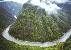
The Yarlung Zangbo Grand Canyon stretches 496 kilometers. The widest span from the peak to the lowest water surface of the river measures about 5,400 meters. The upper reaches, stretching from the riverhead to Lizi, is 268 kilometers in length and spotted with lakes; the middle reaches, from Lizi to Paiqu, stretching 1293 kilometers; and the lower reaches, 496 kilometers.