Located in the east of the Asian continent, on the western shore of the Pacific Ocean, the People's Republic of China has a land area of about 9.6 million square kilometers, and is the third largest country in the world, next only to Russia and Canada.
From north to south, the territory of China spans over 49 latitudes, stretching from the center of the Heilongjiang River north of the town of Mohe to the Zengmu Reef at the southernmost tip of the Nansha. From east to west, the nation extends from the confluence of the Heilongjiang and Wusuli rivers to the Pamirs.
China's coastline measures approximately 32,000 kilometers, with a flat topography, and many excellent docks and harbors, most of which are ice-free all year round. The Chinese mainland is flanked to the east and south by the Bohai, Yellow, East China and South China seas, with a total maritime area of 4.73 million square kilometers. The Bohai Sea is China's continental sea, while the Yellow, East China and South China seas are marginal seas of the Pacific Ocean.
A total of 5,400 islands dot China's territorial seas. The largest of these, with an area of about 36,000 square kilometers, is Taiwan, followed by Hainan with an area of 34,000 square kilometers. The Diaoyu and Chiwei islands, located to the northeast of Taiwan Island, are China's easternmost islands.
China has many mountains, with mountainous areas (traditionally consisting of mountains, hills and rugged plateaus) making up 65% of its total land area. The proportion of various landforms is as follows: Mountains, 33%; plateaus, 26%; basins, 19%; plains, 12%; and hills, 10%.
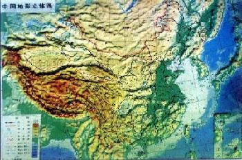
China has a terraced terrain, which gradually descends from the west to the east step by step. The first, or the highest, terrace is the Qinghai-Tibet Plateau, with an average elevation of more than 4,000 meters and known as "the roof of the world". The Qinghai-Tibet Plateau is composed of rows of snow-capped peaks and glaciers. The major mountain ranges are the Kunlun, Gangdise and Himalayas.
The second step consists of the Inner Mongolia, Loess and Yunnan-Guizhou plateaus, and the Tarim, Junggar and Sichuan basins, on an altitude of 1,000-2,000 meters.
The third step, about 500-1,000 meters in elevation, begins at the line from the Greater Hinggan, Taihang, Wushan and Xuefeng mountain ranges eastward to the seacoast. Here, running from north to south are the Northeast Plain, the North China Plain, and the Middle-Lower Yangtze Plain. Interspersed amongst the plains are hills and foothills.
To the east of the third step the shallow waters of the continental shelf, an extension of the land into the ocean, form the fourth step. The depth of the water here is less than 200 meters. Great quantities of mud and sand have been carried here by the rivers on the mainland.